Failed Islamic States in Senegambia
David Robinson
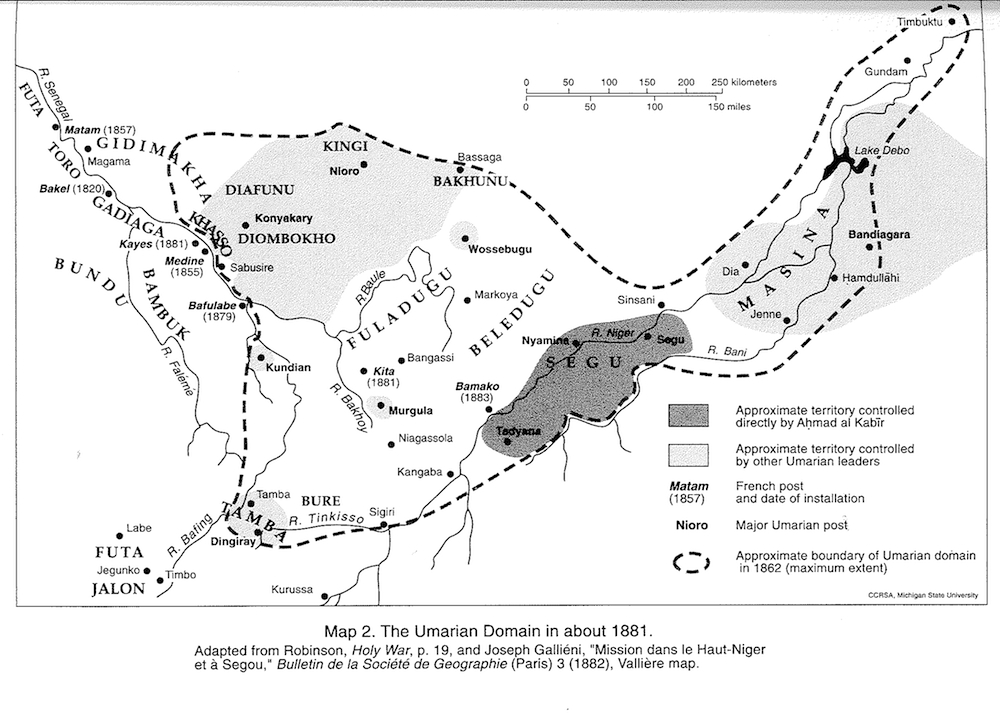
Umarian Domain, 1881
 click image to zoom
Contributing Institutions: David Robinson; MATRIX: The Center for Humane Arts, Letters, and Social Sciences Online at Michigan State University
Description: This map is an effort, by Hanson and Robinson, to estimate the area of Ahmad al-Kabir's dominion about 1881, in contrast to the map entitled Umarian Domain, 1862, which represents the Umarian territories at their maximum extent, for a brief period in 1862. This map, published in 1991, is based on a map in Robinson, Holy War, p 19, and a map drawn by Valliere, part of the Gallieni mission, and appearing in Joseph Gallieni, "Mission dans le Haut-Niger et a Segou," Bulletin de la Societe de Geographie (Paris), 3 (1882). This map contains the following captions, "Map 2. The Umarian Domain in about 1881" "R. Senegal" "Futa" "Matam (1857)" "Toro" "Gidimakha" "Magama" "Bakel (1820)" "Gadiaga" "Bundu" "Diafunu" "Kingi" "Nioro" "Khasso" "Konyakary" "Diombokho" "Kayes (1881)" "Medine (1855)" "Sabusire" "Bambuk" "R. Faleme" "Bafulabe (1879)" "Kundian" "Labe" "Futa" "Jegunko" "Jalon" "Timbo" "R. Bating" "Tamba" "Tamba" "Dingiray" "Kurussa" "Bure" "R. Tinkisso" "Sigiri" "R. Baule" "Bassaga" "Bakhunu" "Wossebugu" "Fuladugu" "R. Bakhoy" "Markoya" "Bangassi" "Kita (1881)" "Murgula" "Niagassola" "Kangaba" "Bamako (1883)" "Tadyana" "Nyamina" "Segu" "R. Niger" "Segu" "Sinsani" "R. Bani" "Dia" "Jenne" "Masina" "Hamdullahi" "Bandiagara" "Lake Debo" "Gundam" "Timbuktu" "Approximate territory controlled directly by Ahmed al Tabir" "Approximate territory controlled by other Umarian leaders" "Matam (1857)-French post and date of installation" "Nioro-Major Umarian post" "Approximate boundary of Umarian domain in 1862 (maximum extent)"
Date: 1991
Date Range: 1990-1999
Location: Senegal
Format: Image/jpeg
Rights Management: For educational use only.
Digitizer: MATRIX
Source: John Hanson and David Robinson, After the Jihad: the Reign of Ahmad al-Kabir in the Western Sudan. Michigan State University Press, 1991. Page 23.


