Failed Islamic States in Senegambia
David Robinson
Documents
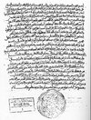
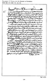
Warning to Muslims in Saint-Louis
Date: 1855A letter written by al-hajj Umar in 1855 to the Muslim inhabitants, and particular the traders, living in Saint-Louis, the capital of French operations in the area located at the mouth of the Senegal River. The French were beginning to expand up the river and to threaten Umarian operations. Consequently Umar warns the Muslim merchants, who had worked closely with the French, not to associate with them, and questions their Muslim identity if they do.
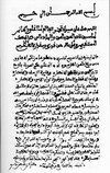
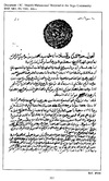
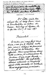
Congratulations from Morocco
Date: October 21, 1860Translation of an excerpt from the leader of the Moroccan Tijani order, al-Kansusi, upon hearing about Umar Tall's main victory over the Bambara of Segu in September 1860. This document, so important for the Umarian cause, is contained in several copies in the Umarian library, which was based in Segu until taken to Paris and the Bibliotheque Nationale in the 1890s by the French, who conquered the whole area and arranged it into French West Africa.
Accusations against Hamdullahi
Date: 1862Translation of excerpts from an Arabic treatise written by Al-hajj Umar in 1861-2 to explain his indictment of the opposition of the Caliphate of Hamdullahi to his jihad, and to justify the attack which he launched in 1862.
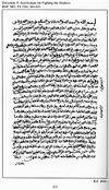
Justification for the Struggle Against the Brothers
Date: 1870A response by Al-Hajj Seydu An, an experienced Islamic scholar, to questions posed by Ahmad al-Kabir about justifications to put down the rebellion of his brothers Habib and Mokhtar. The document was written in 1869 or 1870, just before Ahmad left Segu to put down the rebellion.
Victory over the Bambara at Gemukura
Date: 1872A description of Ahmad al-Kabir's campaign against the Bambara revolt, culminating in the victory of Gemukura in 1872, written by Ahmad's counselor Seydu Jeliya Ture. The document was probably written during the campaign, and not in Segu.
The Massacre at Pete, an Arabic letter
Date: December 20, 1874A letter addressed by an important cleric and political figure writing in Saint-Louis, Senegal, to the leaders of the Umarian community in Segu, in 1874, and commenting on the terrible events at Pete the year before.
Verbal portrait of Umar
Date: 1887Impressions gathered by Paul Soleillet in 1878 in Segu, where he was visiting the capital and court of Umar's son Ahmad al-Kabir. Soleillet's journal was edited and published by Gabriel Gravier in 1887.
Ahmad's Plea to the Sultan of Morocco
Date: May 31, 1893English translation from the French of excerpts of a letter written by Ahmad al-Kabir to the Sultan of Morocco in May 1893, as the French are moving in to his last capital, Bandiagara, and he and his followers are preparing to flee to the east. Ahmad makes a last appeal to Morocco to intervene to save the Dar al-Islam of West Africa.
Critique of the Umarian Movement
Date Range: 1890-1899This document, a poem written in Arabic characters but the Pulaar language, just like the document, Praise Poem of Umar Tall, takes a critical perspective on the Umarian jihad. The author is a griot or traditional, casted historian, is much shorter and puts the emphasis on the violence of warfare, on all sides, and ends up appealing to Umar to return "home," that is, to go back to Futa Toro. Included is a Pulaar transliteration and a French translation of the original.
Praise Poem of Umar Tall
Date Range: 1890-1899This excerpt comes from the beginning of a long poem in praise of Umar Tall and his career as a Muslim pilgrim, scholar and especially a leader of jihad. The poem is a "qasida," an Arabic form of 1200 verses. In this case it is written in Arabic characters but in the Pulaar language spoken by the core of Umar's followers. It was written in the late 19th century by one follower, Mohammadou Aliou Tyam, who lived in the Umarian capital of Segu but returned to Futa Toro after the French conquest of Segu in 1890. His text was transcribed and translated into French by a French Pulaarophone, Henri Gaden, while Gaden was living in Saint-Louis, Senegal and serving in the French administration of Mauritania in the 1930s.
Struggle between Ahmad and Muntaga
Date Range: Late 19th CenturyTranslation from the French which in turn is a translation from an Arabic chronicle of the history of the area of Karta. The chronicle was written by Al-Hajj Umar Kaba Jakhite, an important Soninke leader and scholar living in Nioro. Much of the chronicle deals with the Umarian history of Karta, which is to say the late 19th century.
Triumph over Paganism at Segu
Date Range: 1860-1869English translation of verses from `ajami poem of Mohammadou Aliou Tyam celebrating the triumph over and entry into the Bambara capital of Segu in 1861. Tyam wrote Pulaar in Arabic characters. See document, Praise Poem of Umar Tall.
Drawings
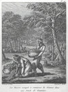
Gum Harvesting in the Senegal Valley
Date: 1802A selection from the French traveler J.B.L. Durand at the beginning of the 19th century. Here we see two slaves, working for Moorish masters, doing the very hard work of picking the gum from the acacia trees that were found in the Senegal River valley. This engraving contains the following caption, "Les Maures occupés à ramasser la Gomme dans une Forêt de Gommiers."
J.B.L Durand Image Gallery
Date: 1802This is a series of images drawn from the pages of J.B.L Durand's 1802 book, Un Voyage au Senegal. The image 'Representative types of Senegal Society' contains the following caption, "1..Négresse esclave. 2..Signare de l'Isle St. Louis. 3..Marabou ou Prêtre du Pays. 4..Négre armé en guerre. 5..Négresse esclave portant son enfant." The image 'Gum Harvesting in the Senegal Valley' contains the following caption, "Les Maures occupés à ramasser la Gomme dans une Forêt de Gommiers." The image 'Slave Raiding' contains the following caption, "Les Maures poursuivant les Nègres pour les faires Esclaves." The image 'Portrayal of Battle of Samba Sadio' contains the following caption, "Colonies Françaises - Le Sénégal. - Combat de Boumdou. - Le marabout Amadou Sekou est battu par la colonne expéditionnaire commandée par le lieutenant-colonel Bégin." The image 'Memorial for Victims of Samba Sadio' contains the following caption, "Religious Service in St. Louis for the Victims of the Battle against Anadu Madiyu, 1875".
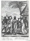
Representative types of Senegal society
Date: 1802An engraving found in the voyage of the French traveler Durand who visited Senegal at the beginning of the 19th century. This engraving contains the following caption, "1..Négresse esclave. 2..Signare de l'Isle St. Louis. 3..Marabou ou Prêtre du Pays. 4..Négre armé en guerre. 5..Négresse esclave portant son enfant."
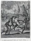
Slave Raiding
Date: 1802Another engraving from the French traveler Durand at the beginning of the 19th century. Moors and other slave-raiders used violent means - including the horses, swords and arson showed here - to secure a slave labor force to do things like harvesting the gum of the last image. This engraving contains the following caption, "Les Maures poursuivant les Nègres pour les faires Esclaves."
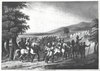
Warfare
Date: 1802Another engraving from the French traveler Durand at the beginning of the 19th century. Here we see an army - cavalry and infantry - preparing to go to battle in the Senegal River valley.
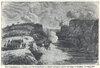
Boats rushing to rescue Medine
Date: 1857Engraving based on a sketch of the French boats going up the Senegal River to rescue the fort of Medine in July 1857 to liberate the fort from the siege organized by Al-Hajj Umar. This engraving contains the following caption, "The Expeditionary Column and the Steamboat Le Basilic going to relieve the siege of Medine, 18 July 1857".
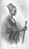
Ahmad al-Kabir in about 1864
Date: 1868A sketch made by the French explorer Eugene Mage, who resided in Segu, Ahmad's capital, from 1864 to 1866. His rough sketch was reworked into a wood engraving by an artist in Paris and published with Mage's account in 1868. This engraving contains the following caption, "S. M. Ahmadou, roi de Ségou."
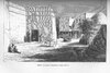
Entrance to Ahmad's Palace in Segu
Date: 1868A sketch made by the French explorer Eugene Mage, who resided in Segu, Ahmad's capital, from 1864 to 1866. His rough sketch was reworked into a wood engraving by an artist in Paris and published with Mage's account in 1868. This sketch contains the following caption, "Entrée du palais d'Ahmadou, à Ségou-Sikoro."
Le Monde Illustre Images
Date: 1875A series of image that appeared in a popular journal which circulated widely in France in the late 19th century. The image 'Portrayal of Battle of Samba Sadio' contains the following caption, "Colonies Françaises - Le Sénégal. - Combat de Boumdou. - Le marabout Amadou Sekou est battu par la colonne expéditionnaire commandée par le lieutenant-colonel Bégin." The image 'Memorial for Victims of Samba Sadio' contains the following caption, "Religious Service in St. Louis for the Victims of the Battle against Anadu Madiyu, 1875".
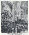
Memorial for Victims of Samba Sadio
Date: 1875An artist's sketch of the religious service for the casualties from the French and Cayorian coalition which defeated the Madiyankoobe at Samba Sadio in February 1875. This sketch contains the following caption, "Religious Service in St. Louis for the Victims of the Battle against Anadu Madiyu, 1875".
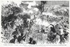
Portrayal of Battle of Samba Sadio
Date: 1875An artists rendering of a journalist's sketch of the Battle of Samba Sadio in February 1875. This drawing contains the following caption, "Colonies Françaises - Le Sénégal. - Combat de Boumdou. - Le marabout Amadou Sekou est battu par la colonne expéditionnaire commandée par le lieutenant-colonel Bégin."
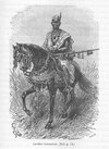
Umarian Horseman with Musket
Date: 1886A sketch made by the French officer and explorer Joseph Gallieni, who traveled through the Western Sudan between 1886 and 1888. His rough sketch was reworked into a wood engraving by an artist in Paris and published with Gallieni's account in 1891. This sketch contains the caption, "Cavalier toucouleur. (Voir p. 54.)"
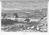
Dingiray, the first Umarian capital
Date Range: 1880-1889Wood engraving completed by an artist in Paris on the basis of a sketch completed by the French traveler, Joseph Gallieni, during his voyage to West Africa between 1886 and 1888, of Umar's first capital and the original homestead of his wives and children, established in 1849. This engraving contains the following caption, "Dinguiray".
Interviews
Massacre at Pete, in interview
Date: January 23, 1968Excerpt from an interview with Ali Gaye Thiam conducted by David Robinson in Mataam, Senegal on 23 Jan 1968. Thiam is from a caste of maabo (pl. maabube), griots or oral historians who were attached to the ruling classes of Fuuta.
Recruiting an Army of Jinns
Date: March 3, 1968Excerpt from an interview with Bani Giise in Pulaar, conducted by David Robinson in Aanam Siwol on 3 March 1968. Bani Giise was an oral historian of Fuuta attached to the Fulbe lineages of the area.
Umar's Trial of Cerno Falil
Date: April 25, 1968Excerpt from an interview with Hammadi Saayande Njaay, conducted in Pulaar / Fula by David Robinson in the town of Kanel, Futa Toro, on 25 April 1968. Njaay was one of the foremost oral historians of Futa, belonging to the caste of maabo (pl. maabube) who performed for the ruling classes of Fuuta Tooro. Pulaar original with English translation provided.
Maps
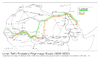
Umar Tall's Probable Pilgrimage Route (1828-1830)
Date: 1972Umar al-Naqar sought to sketch out the main routes by which West Africans journeyed to and from the pilgrimage. The distances were immense, and it was important to join up with other pilgrims and caravans to make the journey, which often took several years. From Umar's own writings, we have sketched out his probable routes going and coming. He made the pilgrimage in three successive years, 1828-30, and so would have been traveling for much of 1827 (going) and 1831 (returning). This new map was made in 1972. This map contains the following captions, "Umar Tall's Probable Pilgrimage Route (1828-1830)" "Algiers" "Rabat" "Fez" "Tlemcen" "Constantin" "Qairawan" "Marrakesh" "Sijilmasa" "Main route of the Maghrib caravans" "Ghadmes" "Sous" "Saghia Al Hamra" "Tuat" "In Salah" "Mansa Musa's route" "Taghza" "Shinqit" "Taudeni" "Ticit" "Haud" "Walata" "Timbuctu" "Arwan" "Podor" "Futa Toro" "Futa Bondu" "Futa Jallon" "Timbo" "Kankan" "Sambatikila" "Bamako" "Kong" "Niono" "Sokolo" "Mopti" "Segu" "Banjagara" "Hombahi" "Gao" "Arbinda" "Say" "Kebbi" "Gwandu" "Sokoto" "Hausa land" "In Gall" "Agadez" "Guat" "Route of the Tuati caravan" "Murzuk" "Katsina" "Hadija" "Kano" "Zaria" "Bauchi" "Yola Adamawa" "Maidugaryo" "Dikwa" "Katagum" "Kuka" "Bornu" "Kanem" "Bilma" "Murzuk" "Aujila" "Jaghbub" "Siwa" "Benghazi" "Alexandria" "Cairo" Jerusalem" "Suez" "Overland route of Mahamal caravan" "Madina" Mecca" "Jidda" "Asiut" "Qusair" "Kharja" "Kufra" "Darb Al-Arba'in" "Selima" "Afade" "Atia" "Masinya" "Bagirmi" "Masinda" "Ndele" "Dar Kuti" "Deim Zubair" "Dar Runga" "Atia" Abbeche" "Wara" "Wadai Dar Fur" "Kobi" "Fasher" "Obied" "Nuhud" "Kafi" Kenji" "Umdurman" "Damar" "Berber" "Aydhab" "Suaken" "Tokar" "Shendi" "Goz Rajab" "Masawa" "Aksum" "Sennar" "Gallabat" "Gondar"
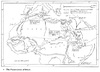
Typical Portrayal of the Spread of Islam in Africa
Date: 1978This is an effort, found in a number of works, to suggest the patterns and paths of the spread of Islam into Africa and especially Sub-Saharan Africa. It comes from an atlas published in 1978 by a highly respected historian and a highly respected cartographer of Africa. This map contains the following captions, "7. The Penetration of Islam" "Spain" "Tarik 711-14" "Gibraltar" "Maghrib" "Uqba" "Carthage (698)" "Kairwan (670)" "Iahuda (683)" "Uqba" "Tripoli (647)" "Barca" "Barca 647" "Alexandria (642)" "Palestine (634)" "Baghdad" "Amr Ibn Al As" "Babylon (Cairo) (641)" "Persian Gulf" "Egypt (640-42)" "Medina (Muhammad died 632)" "Mecca" "Raiding" "Nubia" "Turks" "Dongola" "Dahlak" "Yemen 633" "Zeila" "Ethiopia Christian Kingdom from c. VI C." "L. Tana" "Gran" "Abyssianian Highlands" "E. African Coast" "Onwards" "Lake Victoria" "Egyptians" "Sudan" "Darfur" "Wadai" "Sahara" "Ibn Yasin" "Almoravids" "Nubia-Christian Kingdoms VI-XIII Cs, Arab conquest XIII-XIV Cs" "L. Chad" "Kanem" "Bornu" "Hausaland" "R. Benue" "R. Niger" "Mandingoes" "Songhai" "Gao" "Timbuctu" "Walata" "Ghana (1076)" "R. Senegal" "Almoravids" "Berbers" "Mali" "R. Volia" "R. Congo" "Land over 1000m (3300ft)"
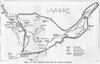
Umarian Domain, 1862
Date: 1991A map published in 1991 showing the maximum extent of the Umarian conquests about 1862, based on Robinson's estimate of the territories taken during the most successful part of the jihad, between 1852 and 1862. It should be contrasted with the much smaller domain controlled by Ahmad al-Kabir about 1881, shown in the map entitled, Umarian Domain, 1881. This map contains the following captions, "Map 1.1: The Umarian State and the French Conquest" "Kaedi" "Futa" "Matam (1857)" "R. Senegal" "Gidimakha" "Toro" "Gadiaga" "Gemu (1859)" "Bakel (1820)" "Senudebu (1845)" "Bulebane" "Kussan" "Khasso" "Kayes (1881)" "Medine (1855)" "Kenieba" "Gundiuru" "Bambuk" "Bundu" "R. Faleme" "Sabucire" "Bafulabe (1879)" "Diafunu." "Koniakary (1890)" "Diombokho)" "Nioro (1891)" "Karta" "Bakhunu" "Wossebugu (1890)" "Sabone" "R. Baule" "Fuladugu" "Kundian (1889)" "R. Bating" "Labe" "Futa" "Jegunko" "Jalon" "Timbo" "Tamba" "R. Bakhoy" "Kita (1881)" "Murgula (1882)" "Dingiray-French protectorate established in 1887" "R. Tinkisso" "Kurussa" "Sigiri" "Kangaba" "Niagassola" "Beledugu" "Bamako (1883)" "R. Niger" "Nyamina (1889)" "Segu" "Segu (1890)" "Sinsani" "R. Bani" "Jenne" "Hamdullahi" "Bandiagara (1839)" "Lake Debo" "Timbuktu" "Matam (1857)-French post and date of installation" "Nioro (1891)-Major Umarian post and date of French capture" "Approximate boundaries of Umarian State in 1862 (maximum extent)"
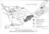
Umarian Domain, 1881
Date: 1991This map is an effort, by Hanson and Robinson, to estimate the area of Ahmad al-Kabir's dominion about 1881, in contrast to the map entitled Umarian Domain, 1862, which represents the Umarian territories at their maximum extent, for a brief period in 1862. This map, published in 1991, is based on a map in Robinson, Holy War, p 19, and a map drawn by Valliere, part of the Gallieni mission, and appearing in Joseph Gallieni, "Mission dans le Haut-Niger et a Segou," Bulletin de la Societe de Geographie (Paris), 3 (1882). This map contains the following captions, "Map 2. The Umarian Domain in about 1881" "R. Senegal" "Futa" "Matam (1857)" "Toro" "Gidimakha" "Magama" "Bakel (1820)" "Gadiaga" "Bundu" "Diafunu" "Kingi" "Nioro" "Khasso" "Konyakary" "Diombokho" "Kayes (1881)" "Medine (1855)" "Sabusire" "Bambuk" "R. Faleme" "Bafulabe (1879)" "Kundian" "Labe" "Futa" "Jegunko" "Jalon" "Timbo" "R. Bating" "Tamba" "Tamba" "Dingiray" "Kurussa" "Bure" "R. Tinkisso" "Sigiri" "R. Baule" "Bassaga" "Bakhunu" "Wossebugu" "Fuladugu" "R. Bakhoy" "Markoya" "Bangassi" "Kita (1881)" "Murgula" "Niagassola" "Kangaba" "Bamako (1883)" "Tadyana" "Nyamina" "Segu" "R. Niger" "Segu" "Sinsani" "R. Bani" "Dia" "Jenne" "Masina" "Hamdullahi" "Bandiagara" "Lake Debo" "Gundam" "Timbuktu" "Approximate territory controlled directly by Ahmed al Tabir" "Approximate territory controlled by other Umarian leaders" "Matam (1857)-French post and date of installation" "Nioro-Major Umarian post" "Approximate boundary of Umarian domain in 1862 (maximum extent)"


